|
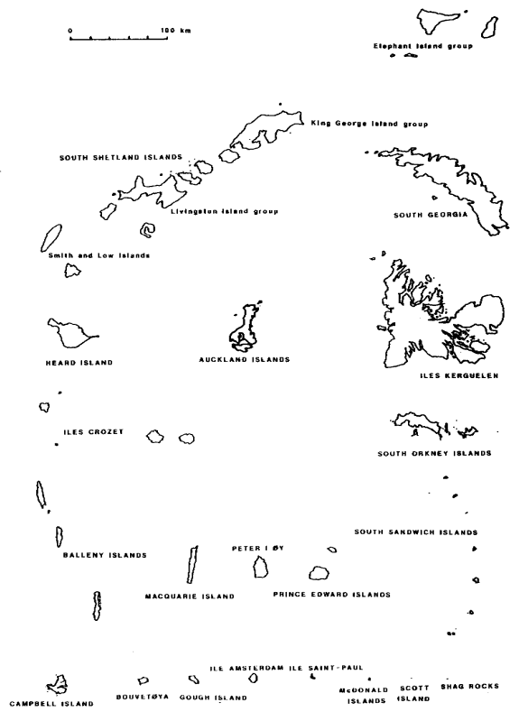
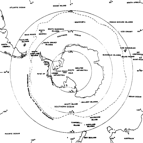
MAPS
OF THE PERI-ANTARCTIC ISLANDS
The islands
and archipelagos mentioned here are referred to as peri-Antarctic, rather
than sub-Antarctic, since many of them are similar in features despite
their location outside the Antarctic Convergence Zone. The geographical
co-ordinates listed for the smaller islands are based upon the middle
of the island. It should be noted that historical dates given for sightings,
landings and winterings are the first recorded incidences. Sovereignty
over some of these islands is still disputed. This list is presented
in an easterly order, from 0° longitude.
Bouvetøya ,
54°25'S : 3°22'E
- Also known as
Bouvet, this island is a single volcanic island with an offlier. The
island covers 54 km² with its highest elevation being Mt.
Olavtoppen at 780 m. It is 93% glacierized. Discovered by Jean
Baptiste Charles de Lozier Bouvet on January 1, 1739, the first
recorded landing was by sealers in 1822. The island is uninhabited
with no wintering population, and is a dependency of Norway (claimed
in 1927).
Prince Edward
Islands, 46°36' to 46°58'S : 37°35' to 38°01E
- The group consists
of two main islands, Prince Edward Island and Marion Island. They
are separated by 22 km and are of volcanic origin with a number of
outliers. The two islands cover 317 km² with the highest
elevation, State President Swart Peak, located on Marion Island. The
group was first sighted in 1663 with the first landing, by sealers,
in 1799. A scientific station was established in 1947 and has been
occupied permanently since. The Prince Edward Islands are a state
territory of the Republic of South Africa.
Iles Crozet,
45°57' to 46°30'S : 50°20' to 52°35'E
- The Crozet Islands
consist of five islands in two island groups: Ile aux Cochons with
Ilots des Apôtres and Ile des Pingouins; Ile de la Possession
and Ile de l'Est. Separated by a total of approximately 100 km, these
islands are of volcanic origin. The group covers 325 km² with
the highest elevation being Pic Marion-Dufresne (1090 m) on Ile de
l'Est. The first sighting and landing took place in 1772 by French
navigator Marion-Dufresne. A scientific station was established in
1963 and has been occupied permanently since. The islands are French
territory, part of Terres Australes et Antarctiques Françaises
(French Southern Antarctic Territories).
Iles Kerguelen,
48°35' to 49°44'S : 68°43' to 70°35'E
- The Kerguelen
Islands consist of one large island (Grande Terre) and several smaller
ones. Additionally, there are some 300 islets, rocks and outliers.
The group is partly volcanic in origin. The group covers 7215 km²
with the highest elevation being Mt. Ross at 1850 m. The islands
are 10% glacierized. The first sighting and landing took place in
February 1772 by French navigator Yves-Joseph de Kerguélen-Trémarec.
A scientific station was established in 1951 and has been occupied
permanently since. The group was annexed by France in 1893 and became
part of Terres Australes et Antarctiques Françaises in 1955.
Heard Island,
52°58' to 53°12'S : 73°15' to 73°50'E
- This island is
of volcanic origin along with one smaller island, Shag Island, 11
km to the north. The island covers 385 km² with the highest
elevation being Mawson Peak at 2745 m. This is the highest point in
Australian territory. The island was arguably first sighted in 1833
and again in 1848. The first confirmed sighting was in 1853 with sealers
first landing in 1855. The island came under Australian control in
1947. This is an Australian External Territory, known as the Territory
of Heard and McDonald Islands. The island is uninhabited, however
a scientific station was occupied from 1947-55.
McDonald Islands,
53°03'S : 73°36'E
- This group consists
of one small island with a number of offliers, 38 km west of Heard
Island. Of similar origin to Heard Island, this tiny island only covers
2.6 km² with the highest elevation being Maxwell Hill at
212 m. This unglacierized island, never inhabited, was first sighted
in 1854 with the first landing coming in 1971. This is an Australian
External Territory, known as the Territory of Heard and McDonald Islands.
Ile Amsterdam,
37°50'S : 77°31'E
- Amsterdam Island
is a tiny volcanic island with offlier, about 90 km north of Ile Saint-Paul.
Covering 85 km², the highest elevation is Mont de la Dives at
881 m. The unglacierized island was first sighted in 1522 with the
first landing coming in 1696. A scientific station was established
in 1949 and has been occupied permanently since. The island is French
territory, part of Terres Australes et Antarctiques Françaises.
Ile Saint-Paul,
38°43'S : 77°32'E
- Saint Paul Island
is one small island and offlier of volcanic origin, about 90 km south
of Ile Amsterdam. Only 7 km², the highest elevation is Crête
de la Novara at 268 m. This unglacierized island was sighted before
1559, with the first landing coming in 1696. It is uninhabited, although
various sealers and scientific personnel have wintered over. This
island is French territory, part of Terres Australes et Antarctiques
Françaises.
Macquarie Island,
54°37'S : 158°58'E
- Macquarie Island
consists of one main island with several outliers (Judge and Clerk
Islands). The island is of sedimentary origin and covers 128 km²
with the highest elevation being Mt. Hamilton at 433 m. This
unglacierized island was first sighted and landed upon by sealers
in 1810. Permanent occupation of a scientific station has occurred
since 1948. An Australian State territory, Macquarie Island is a Dependency
of Tasmania. (Macquarie Island
map).
Balleny Islands,
66°15' to 67°35'S : 162°30' to 165°00'E
- This chain of
islands and offliers stretches for 190 km. The group contains three
main islands: Young, Buckle and Sturge. The group covers 400 km²
with the highest elevation, 1524 m., being Brown Peak on Sturge Island.
The group is 95% glacierized. The islands have never been inhabited,
however they were first sighted and landed upon in 1839. They are
New Zealand territory, part of the Ross Dependency.
Auckland Islands,
50°29' to 50°56'S : 165°52' to 166°20'E
- The group consists
of one main island with several smaller ones and offliers. The islands,
of ancient volcanic origin, cover 626 km² with the highest
elevation being Mt. Dick, on Adams Island, at a height of 667 m. The
unglacierized group was first sighted in 1806, with sealers the first
to land in 1807. This New Zealand territory is uninhabited, however
sealers, scientific personnel and a colonial settlement have wintered
over.
Campbell Island,
52°33'S : 169°09'E
- Campbell Island
is of ancient volcanic origin with offliers. It is unglacierized and
covers an area of 113 km² with the highest elevation being
Mt. Honey at 567 m.. It was sighted and first landed upon by sealers
in 1810. A scientific station was established in 1941 and has been
occupied permanently since. The island is New Zealand territory.
Scott Island,
67°24'S : 179°55'E
- Scott Island
is one small island and an isolated stack, of volcanic origin. The
tiny island covers only 0.4 km² with the highest elevation
being Haggits Pillar at 63 m. The island is largely glacierized. Uninhabited,
the island was first sighted and landed upon in 1902. It is New Zealand
territory, part of the Ross Dependency.
Peter I Øy,
68°51'S : 90°37'W
- Uninhabited Peter
I Island is of volcanic origin with an area of 157 km². The highest
elevation is Mt. Lars Christensentoppen at 1640 m. The island is 95%
glacierized. Although first sighted in 1821, the first landing did
not come until 1929. The island is a Norwegian dependency.
South Shetland
Islands, 61°00' to 63°22'S : 53°50' to 62°50'W
- This group stretches
some 540 km and consists of four primary groups, including eleven
major islands (Elephant and Clarence Islands; King George and Nelson
Islands; Robert, Greenwich, Livingston, Snow and Deception Islands;
Smith and Low Islands). There are several smaller islands with many
islets and rocks. Some of the islands are of volcanic origin and average
about 120 km north of the Antarctic Peninsula. A giant among the peri-Antarctics,
the group covers 4662 km² with the highest elevation being
Mt. Foster, on Smith Island, at a height of 2105 m. The group is 80%
glacierized. The South Shetlands were first sighted in 1819 with sealers
arriving in 1820. Permanent scientific operations have occurred since
1943, with a whaling station operating on Deception Island from 1912-31.
This is highly disputed territory as the British have claimed it as
part of its British Antarctic Territory, Argentina as part of Antártida
Argentina and Chile as part of Territorio Antártico Chileno.
South Orkney
Islands, 60°30' to 60°50'S : 44°15' to 46°15'W
- The group consists
of four major islands: Coronation, Signy, Powell and Laurie Islands,
with several minor islands, offlying islets and rocks. Inaccessible
Islands lie 30 km to the west and all are of sedimentary origin. They
cover 622 km² with the highest elevation being Mt. Nivea,
on Coronation Island, at 1265 m. The group is 85% glacierized. They
were first sighted and landed upon by sealers in 1821. A permanent
scientific station has been occupied since 1903. A whaling station
operated at Signy Island between 1920 and 1926. Another disputed island
group, the South Orkneys are claimed by the British as part of the
British Antarctic Territory while Argentina claims them as part of
Antártida Argentina.
Shag Rocks,
55°33'S : 42°02'W
- These six isolated
rocks, and outlying Black Rock, are approximately 250 km west of the
island of South Georgia. They are sedimentary in origin and cover
an area of 0.2 km² with the highest elevation being 71 m. These
unglacierized rocks were probably sighted in 1762 and 1794, however
the first confirmed sighting did not come until 1819. The uninhabited
rocks were first landed upon in 1956. The rocks are claimed as British
territory, being part of South Georgia and the South Sandwich Islands.
Not to be outdone, they are also claimed by Argentina as part of the
Islas del Atlántico Sur.
South Georgia,
53°30' to 55°00'S : 35°30' to 38°40'W
- South Georgia
consists of one main island, several small ones, and numerous islets
and rocks. The outlying Clerke Rocks are 74 km southwest of the main
island and all are mainly of sedimentary origin. Covering an area
of 3755 km², the highest peak is Mt. Paget at an elevation of
2934 m. The island is 57% glacierized. The island was first sighted
in 1675 and landed upon in 1775. Sealers arrived in 1786 and operated
off and on, in conjunction with whaling stations, until 1965. The
island has been permanently occupied by whaling and / or scientific
stations since 1904. South Georgia is claimed as British territory
and is part of the inclusive territory of South Georgia and the South
Sandwich Islands. The island is also claimed by Argentina as part
of the Islas del Atlántico Sur.
South Sandwich
Islands, 56°18' to 59°28'S : 26°14' to 28°11'W
- This group is
a chain of eleven small volcanic islands stretched out over 390 km.
They cover an area of 310 km² with the highest elevation
being Mt. Belinda, on Montague Island, at a height of 1375 m. The
group is 80% glacierized. First sighted in 1775, the first to land
were sealers in 1818. They are uninhabited, although scientific personnel
have wintered over. They are claimed as British territory and are
part of the inclusive territory of South Georgia and the South Sandwich
Islands. The islands are also claimed by Argentina as part of the
Islas del Atlántico Sur.
Gough Island,
40°19'S : 09°57'W
- This unglacierized
island, and several rocks, is of ancient volcanic origin. Covering
an area of 65 km², the highest elevation is Edinburgh Peak at
910 m. It was probably sighted in 1505 with the first landing in 1675.
Sealers arrived to the island in 1804. A scientific station has been
occupied since 1955. Claimed as British territory, the island is part
of the Dependencies of Saint Helena.
BIBLIOGRAPHY:
"Chronological
List of Antarctic Expeditions and Related Historical Events", by
Robert K. Headland
"Merriam Webster's
Geographical Dictionary", Third Edition
|